The Battlefield Trail
The Bridge
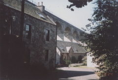
Park the car at the Bridge Inn at Linlithgow Bridge. The pub serves good food and a pint and is an ideal base to plan the walk ahead or refresh yourself after the walk. The buildings used to be a toll house for traders crossing the bridge. It was not around at the time of the battle. It does however indicate that the bridge has been repositioned, as the old bridge carried the road up alongside the inn.
Make your way across the new Linlithgow Bridge taking the chance to peer over the parapet on the upstream side and appreciate the problems Lennox men would have had fording the river at this point. There are also fine views of the Victorian viaduct from here. To the west behind the pub is Manuel Hill, which dominates the approach to the bridge and a likely position for Lennox’s artillery. Looking east along the main road it is difficult to discern the contours of the land as they are now covered in housing but the ground steadily rises towards the viaduct. It is likely that Arran placed cannon overlooking the bridge along what is now Mill Road.
After crossing the bridge and at the traffic lights turn right along Mill Road. Then take the next the next right down to the Burgh Mills. Just before the beautifully restored buildings of the mill itself you will find a footpath signposted as the Avon Heritage Trail leading off to your left and down the side of the first mill house. Be warned this is slippy when wet. It takes you under the arches of the viaduct towering above you. Once down the slope and against the river, it is time to take stock.
Pace Hill
As you walk south, the slopes of Pace Hill reveal themselves to your left. It is easy to get overwhelmed by the man made slope created to support the railway and access the quarry. But as you move along the natural contours become easier to discern. We suspect that the slope you see today is much steeper than that of 1526 but the change in height is discernable and gives you a good idea of the problem Lennox faced in attacking it. Note also the ground. It is still marshy despite the presence of the quarry and argricultural drainage. Even after a fair summer the land in September retains a spongy texture.
As you walk south, the wasteland at the foot of Pace Hill gives way to the quarry site. Beyond the water rises the slope up to the Torphichen Road. It gives a clear sense of the ampitheatre into which Lennox advanced. Also make a mental note of the distance to the rising ground. It is the funnelling affect of the terrain here that nullified any advantage Lennox had in numbers. Harquesbus and cannon could easily disrupt the advance from the ridge.
To your right across the other side of the Avon is well drained farm land which in 1526 was water meadow associated with the Manuel Nunnery. The fields rise up to the Whitecross road and Manuel Haugh Farm. Beyond the farm the buildings of Whitecross can just be made out on the ridge line. However things are not all that they seem. Recent research suggests the course of the river has radically changed during the 18th and 19th Century due to the construction of the mills and the associated weirs and laids. In fact the river ran some 200 yds to the north west at this point in the 16th Century giving Lennox a little more room to manaoueuvre than we see today.
The stretch of woodland along the river bank you are now walking through has been a noted feature on all the early maps and there is no reason to think that it was note in a similar state on the day. It is easy to imagine Arran’s men using it as cover to watch the enemy move towards the Nunnery on the far side of the meadow, taking the odd pot shot every now and then to keep them on their toes. Like wise, Lennox’s horsemen may have ventured along the west bank to look for a good crossing point before driving the Hamiltons away from the ford at the nunnery.
 The Manuel Nunnery
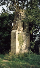
After about 1½ kilometres the field on the west side of the river peters out and nestled in the trees on the far bank towers the gable end of the Manuel Nunnery. It is quite an impressive and unexpected sight. The boulders and rocks that are strewn around the riverbank mark the remains of the convent and, unless you walk in winter when the river is at its highest, it is difficult to believe that the building was torn down by the power of the flooded Avon as the local legend has it. Recent research has proven that it was the man made efforts to divert the river for industrial use that eventually changed the course of the water and undermined the Nunnery foundations. Take a minute to contemplate that the cemetery for the Nunnery lay traditionally on the south side, that is to say where you are now standing !
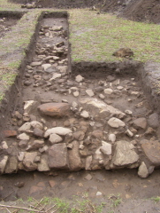
 Archaeological digs that took place in 2007 have proven that the Nunnery was quite an impressive and unique structure. It appears that due to the proximity of the river, all the associated buildings usually found on the south side of the chapel were actually on the northside. Geophysical surveys have also detected many more structures neighbouring the ecclesiastical compound and undoubtedly the land now occupied by the water treatment plant and the farmsteads were also covered with buildings. It is no wonder Edward 1 stayed overnight on his way to Falkirk.
The Ford
Just beyond the ruins of the nunnery opposite the Manuel Burn which empties out into the Avon, is what could be the site of the all important ford. Certainly the river runs shallow at this point and during times of drought the river bed can be seen to be level and quite firm.
Looking back along the way you came, you can now really imagine the task that lay ahead of Lennox when he crossed the ford at Manuel. To the east lies a water meadow now some 300 metres wide before it rises up to the sprawling Woodlescote Farm. If you advocate the theory that the battle was fought at Peace Hill with the adversaries facing north - south then you will appreciate the march that Lennox’s pikemen now faced. Hemmed in by the ridge and the river the chances of keeping your formation would seem limited.
Alternatively if you favour the east west disposition of the forces then the ridge up to the works surmounted by its chimney stack would be your obstacle, lined with Hamilton’s troops or be it thinly.
For those of you wanting to return for the pie and pint at the pub it is now best to start back north retracing your steps. Otherwise it is onwards passed the very impressive remains of Manuel Mill on the far bank and climb up onto the Union Canal aquaduct. Once at the canal and walk east until you meet the Torphichen Road. You can come back into town along the road. Unfortunately it’s a busy road, so take care. Or you can follow the canal ... not so busy!
Back along the Road
As you make your way back along the road you will pass the salvage works on your left and approach the roundabout for the Kettlestoun Estate. All along this road across the fields to your left,are the best views of Peace Hill, the valley floor and the crest which Arran defended. It is a fair walk from the convent to the foot of Pace Hill even today but imagine this over boggy ground, carrying an 18ft pike, then charging up hill into the face of those guns and into the hedgerow of pikes at the crest. It is hard to believe that Lennox’s men made it that far!
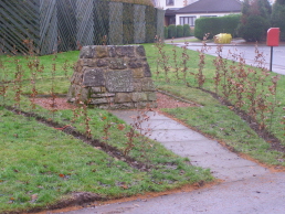
 The road brings you out at the roundabout at the Kettlestoun estate. On the far side of the road you will find The Lennox Cairn. Somewhere in the estate of modern houses lies the true spot of Lennox's murder. The road into town passed the Rugby club is the probable approach of Douglas’s men, Sir Andrew Wood of Largo and eventually the king up from the Westport.
Back Along the Canal
Alternatively instead of coming long the road, carry on along the towpath until you get past the leisure centre then carefully descend onto the footpath that runs along the boundary of the centre and the adjoining estate. This takes you past the site of the old Kettlestoun Farm and up to the entrance to the new estate and leisure centre. Here you will find the Lennox Cairn.
And Finally...
Take the road opposite the cairn and you are back on Mill road. To your left is the crest of Pace Hill, Arran’s chosen fighting ground. Take a minute to view the approach from Arrans point of view and ask yourself what you would have done in his position as he watched Lennox’s flank march develop. Now pass under the railway and you will find yourself back at the Linlithgow Bridge, the Bridge Inn and that well-earned pint and a bite to eat.

